Wharfedale Grange circular walk
|
Circular walk on the west side of Burley to Wharfedale Grange, with refreshments available half way round.
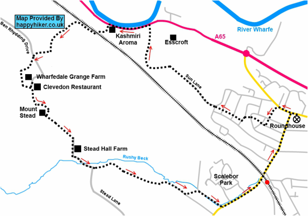
Published in Burley Village Handbook 2015 Distance: 4.2 miles (6.5 km) Ascent: 470 feet (140 metres) Time: 1 ½ to 2 hours Summary The walk starts at the Roundhouse and uses ginnels to cross the village to get to Sun Lane, passing the Nature Reserve, and then field paths to reach the A65. A five minute walk along the gravel path on the A65 road side is followed by a well surfaced track through woodland that rises to the end of Ben Rhydding Drive. A short stretch of lane and footpath leads to the entrance of Clevedon House where the restaurant provides tea, coffee and home-made cakes for walkers at the half way stage (or more substantial offerings), including from their terrace with superb views towards Burley. Field paths then lead down to Stead Lane, where after walking through Stead, further field paths gently descend to Scalebor Park and Moor Lane and back to the village. Although most of the route is on well-maintained tracks and paths, some short stretches may become muddy. There are five stiles on the route and a number of kissing gates. |
The route
From the Roundhouse turn left and walk along Main Street towards Ilkley. Turn left along the ginnel that skirts around the Burley Social Club car park, crossing over Aireville Terrace to follow the ginnel to Manse Road. Turn right and pick up the ginnel directly opposite the junction, crossing Midgley Road to reach West View Avenue. Turn left and quickly right to walk along the ginnel that then crosses Mansfield Road and Wrexham Road to reach Sun Lane. Walk straight ahead to Sun Lane as it becomes a track, keeping right. Walk past the two entrances to the nature reserve to cross the stone step stile at the end of the track. After crossing the plank bridge bear left, keeping the fence to your right to reach a wood step stile with a small beck on the other side. Cross the beck and bear right to a step stile next to a wooden gate, and then follow the track to the wobbly step stile and gate on the A65.
Do not cross the road, but turn left to walk along the gravel path for 5 minutes to reach the footpath sign on the far side of the Kashmiri Aroma car park. Turn left up the track, turning right at the T junction and then left under the railway arch to the kissing gate. Turn right to climb above the railway line with good views emerging of Denton House on the far side of the valley. The track bears left climbing up between mixed woodland with views westwards towards Beamsley Beacon. Large boulders half way up the track make a good resting spot. After 5 minutes reach a gate and follow the footpath sharp right to reach a second gate. Follow the old metal fence on the left as it curves round to meet Ben Rhydding Drive and exit the field through the double gate. Cross over Ben Rhydding Drive to the lane directly opposite, continuing uphill passing High Croft Bungalow. At the end of the wooden fence of a small sandy riding area, turn left through a squeeze stile. Keeping the fence on your left (please watch small children near the rather low rusty barbed wire), follow the path for 5 minutes until it reaches a lane. Turn left past Wharfedale Grange to reach Clevedon Restaurant, which is a Walkers are Welcome establishment. If you wish to have a well-earned refreshment stop, the entrance to the restaurant is facing you, with the terrace to the right hand side (the restaurant request that any muddy boots are left at the door!).
To continue with the second half of the walk, turn left after leaving Clevedon House to walk up the hill, marked as a private road, shortly to turn left through a wooden kissing gate. Walk down through trees to reach a further kissing gate, crossing a stone slab bridge. Take the left hand path to walk slightly downhill with the Chevin straight ahead. Cross a hidden plank bridge and walk straight ahead to skirt around Mount Stead before crossing a step stile and a kissing gate. Follow the path, still with the Chevin ahead with a wall on the right hand side. There are now extensive views to the right over Burley Moor and to the left across the Wharfe valley. Keep straight ahead where a footpath crosses to reach a stone stile formed partly by a boundary stone on the left side inscribed with ‘No 11912’. Keep straight ahead with the fence on the left to reach a large kissing gate in the left hand corner of the field. Exit the path through another large kissing gate to turn right and walk down the track through Stead Hall Farm. Follow Stead Lane as it bears left until a sharp right hand bend. Go straight ahead on the bend through the metal kissing gate to walk downhill through the field to another kissing gate. Follow the well-defined enclosed path through the large field with the wall on your right to reach a metal kissing gate, and an enclosed path down to a track. Turn right passing a small group of houses on your left, then bear left down a sandy path to reach the perimeter of Scalebor Park. Turn right down the track to pass the Community Trust’s playing fields and to reach Moor Lane. Turn left and under the railway line to walk down Station Road to return to your starting point.

